The London Daily Newsletter Tuesday 8 August The London Necropolis Railway was opened in 1854 as a reaction to severe overcrowding in London’s existing graveyards and cemeteries. The magic of the old Covent Garden Market is evoked through Clive Boursnell’s photographs, taken over the course of numerous visits to Covent Garden in the 1960s and 1970s.
The London Daily Newsletter Tuesday 8 August The Hungerford Stairs were the entrance point to Hungerford Market from the River Thames. They are now the site of Charing Cross railway Station. Photographer Luke Agbaimoni created the Tube Mapper project allowing him to be creative, fitting photography around his lifestyle and adding stations on his daily commute.
The London Daily Newsletter Tuesday 8 August The Hungerford Stairs were the entrance point to Hungerford Market from the River Thames. They are now the site of Charing Cross railway Station. Photographer Luke Agbaimoni created the Tube Mapper project allowing him to be creative, fitting photography around his lifestyle and adding stations on his daily commute.
The London Daily Newsletter Monday 7 August A local West Hampstead builder, Thomas Potter, constructed Cedars in 1878. The magic of the old Covent Garden Market is evoked through Clive Boursnell’s photographs, taken over the course of numerous visits to Covent Garden in the 1960s and 1970s.
The London Daily Newsletter Monday 7 August Leytonstone is an area of east London and part of the London Borough of Waltham Forest . Photographer Luke Agbaimoni created the Tube Mapper project allowing him to be creative, fitting photography around his lifestyle and adding stations on his daily commute.
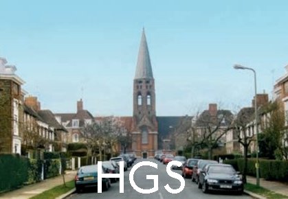
Hampstead Garden Suburb Hampstead Garden Suburb is a suburb, north of Hampstead, west of Highgate, and east of Golders Green. It is an example of early twentieth-century domestic architecture and town planning located in the London Borough of Barnet in northwest London. The master plan was prepared by Barry Parker and Sir Raymond Unwin.
TUM Book Club: Old Covent Garden The magic of the old Covent Garden Market is evoked through Clive Boursnell’s photographs, taken over the course of numerous visits to Covent Garden in the 1960s and 1970s. In the late 1960s and early 1970s Clive Boursnell, then a young photographer, shot thousands of photographs of the old Covent Garden, documenting the end of an era before the markets moved out of central London. Boursnell captured these last days of the market over a period of six years, from 1968 until the market’s closure, in a series of beautiful portraits of the feisty life of a city institution.
Camberwell Flats by Night (1983)
David Hepher (b.1935) is best known for his paintings of buildings, mainly tower blocks, which he refers to as “urban landscapes”.
‘Camberwell Flats’ is part of a series of paintings, two of which can be found at the Museum of London and another at the Middlesborough Institute of Modern Art. They reflect Hepher’s sustained focus on residential architecture, and details of ordinary, everyday life, sometimes pushing it to the brink of abstraction.
Fulham Fulham is an area in the London Borough of Hammersmith and Fulham, SW6 (the successor to the Metropolitan Borough of Fulham). Fulham lies on the north bank of the Thames, between Putney and Chelsea. The area is identified in the London Plan as one of 35 major centres in Greater London. It was formerly the seat of the diocese of Fulham and Gibraltar, and Fulham Palace served as the former official home of the Bishop of London (now a museum), the grounds of which are now divided between public allotments and an elegant botanical garden.
The area is home to the Fulham Football Club stadium Craven Cottage and the Chelsea Football Club stadium Stamford Bridge and the various flats and entertainment centres built into it.
Famously exclusive sports club, the Hurlingham Club, is also located within Fulham. With members having included British monarchs, the waiting list for membership currently averages over fifteen years.
Fulham Broadway has undergone considerable pedestrianisation and is home to a number of cafes, bars and salons.
Fulham has several parks and open spaces of which Bishop’s Park, Fulham Palace Gardens, Hurlingham Park, South Park, Eel Brook Common and Parsons Green are the largest. Many of the residential roads in Fulham are tree-lined, in some cases by houses painted in different pastel shades.
Fulham has appeared in a number of films, including The Omen and The L-Shaped Room. Fulham Broadway tube station was used in Sliding Doors.
Fulham is home to several schools, including independent pre-preparatory and preparatory schools.
TUM Book Club: Tube Mapper Project Photographer Luke Agbaimoni created the Tube Mapper project allowing him to be creative, fitting photography around his lifestyle and adding stations on his daily commute. The Underground is the backbone of the city of London, a part of our identity. It’s a network of shared experiences and visual memories, and most Londoners and visitors to the city will at some point have an interaction with the London Underground tube and train network. Photographer Luke Agbaimoni gave up city-scape night photography after the birth of his first child, but creating the Tube Mapper project allowed him to continue being creative, fitting photography around his new lifestyle and adding stations on his daily commute. His memorable photographs consider such themes as symmetry, reflections, tunnels and escalators, as well as simply pointing out and appreciating the way the light falls on a platform in an evening sunset. This book reveals the London every commuter knows in a unique, vibrant and arresting style.
Dewhurst Road, Hammersmith
Artist: Adam Raven (1952–2006)
Pontoon Dock Pontoon Dock station opened when, on 2 December 2005, the King George V branch of the DLR (since extended to Woolwich Arsenal) was open to the public. Pontoon Dock is located in the east of Silvertown in the redevelopment zone known as Silvertown Quays.
The station is near to the small eponymous quay, Royal Wharf – a large commercial and residential development on the riverside – and the Barrier Point residential complex.
Royal Wharf covers a location previously owned by Brunner Mond, where the Silvertown explosion occurred and where there is a small memorial.
During the 2012 London Olympic games, Pontoon Dock was connected by a pathway over the road to the exit of the ExCeL centre.
TUM Book Club: Old Covent Garden The magic of the old Covent Garden Market is evoked through Clive Boursnell’s photographs, taken over the course of numerous visits to Covent Garden in the 1960s and 1970s. In the late 1960s and early 1970s Clive Boursnell, then a young photographer, shot thousands of photographs of the old Covent Garden, documenting the end of an era before the markets moved out of central London. Boursnell captured these last days of the market over a period of six years, from 1968 until the market’s closure, in a series of beautiful portraits of the feisty life of a city institution.
Child’s Hill: Harrow in the Distance – (1825)
The painting shows the view northwest along what is now Cricklewood Lane, with Harrow on the Hill visible beyond.
Collection of the Victoria & Albert Museum.
St Giles St Giles is a district of central London, at the southern tip of the London Borough of Camden. There has been a church at St Giles since Saxon times, located beside a major highway. The hospital of St Giles, recorded c. 1120 as Hospitali Sancti Egidii extra Londonium was founded, together with a monastery and a chapel, by Queen Matilda, wife of Henry I. St Giles (c. 650 – c. 710) was the patron saint of lepers and the hospital was home to a leper colony, the site chosen for its surrounding fields and marshes separating contagion from nearby London.
A village grew up to cater to the brethren and patients. The crossroads which is now St Giles Circus, where Oxford Street, Charing Cross Road, Tottenham Court Road and New Oxford St meet, was the site of a gallows until the fifteenth century. Grape Street, in the heart of the St Giles district, runs beside the site of the hospital’s vineyard.
The monastery was dissolved during the Reformation and a parish church created from the chapel. The hospital continued to care for lepers until the mid sixteenth century, when the disease abated and the hospital instead began to care for indigents. The parish was known as St Giles in the Fields and it is recorded in 1563 as Seynt Gyles in the Field.
The first post-Catholic parish church was built in 1631 and from the mid-seventeenth century church wardens note “a great influx of poor people into this parish”.
The 1665 Great Plague started in St Giles and the first victims were buried in the St Giles churchyard. By September 1665, 8000 people were dying a week in London. By the end of the plague year there were 3216 listed plague deaths in St Giles parish, which had fewer than 2000 households. After the Restoration, the area was populated by Huguenot refugees who had fled persecution and established themselves as tradesmen and artisans, particularly in weaving and the silk trade.
The southern area of the parish, around present day Shaftesbury Avenue, was a wasteland named Cock and Pye Fields. Houses were not built there until 1666, after the Great Fire, and not fully developed until 1693, becoming known as Seven Dials. Thomas Neale built much of the area, giving his name to Neal Street and Neal’s Yard. St Giles and Seven Dials became known for their astrologers and alchemists, an association which lasts to this day. The village of St Giles stood on the main road from Holborn to Tyburn, a place of local execution. Convicted criminals were often allowed, in tradition, to stop at St Giles en route to Tyburn for a final drink – a St Giles Bowl – before hanging.
The ancient parish of St Giles in the Fields formed part of the Ossulstone hundred of Middlesex. The parish of St George Bloomsbury was split off in 1731, but the parishes were combined for civil purposes in 1774 and used for the administration of the Poor Law after the Poor Law Amendment Act 1834.
As London grew in the 18th and 19th centuries, so did the parish’s population, rising to 30 000 by 1831. The Rookery stood between the church and Great Russell Street, and Seven Dials near where Centre Point stands today, now home to the Centrepoint homeless charity. It was of one of the worst slums within Britain, a site of overcrowding and squalor, a semi-derelict warren. From Georgian affluence in the 18th century, the area declined rapidly, as houses were divided up, many families sharing a single room. Irish Catholic immigrants seeking to escape desperate poverty took up residence and the slum was nicknamed ’Little Ireland’ or ’The Holy Land’. The expression “a St Giles cellar” passed into common parlance, describing the worst conditions of poverty. Open sewers often ran through rooms and cesspits were left untended. Residents complained to the Times in 1849 : “We live in muck and filth. We aint got no priviz, no dust bins, no drains, no water-splies, and no drain or suer in the hole place.” The rookery was a maze of gin shops, prostitutes’ hovels and secret alleyways that police had little of hope navigating. William Hogarth, Thomas Rowlandson and Gustav Dore, among others, have drawn the area, novelists Henry Fielding and Charles Dickens have written about it extensively. Peter Ackroyd writes “The Rookeries embodied the worst living conditions in all of London’s history; this was the lowest point which human beings could reach”.
From the 1830s to the 1870s plans were developed to demolish the slum as part of London wide clearances for improved transport routes, sanitation and the expansion of the railways. New Oxford Street was driven through the area to join the areas of Oxford Street and Holborn. The Rookery dwellers were not re-housed by the authorities. 5000 were evicted and many just moved into near by slums, such Devil’s Acre and Church Lane making those more overcrowded still. The unchanging character of the area, failing investment schemes and inability to sell new properties ensured that plans for wholesale clearance were stymied until the end of the century.
Upon the creation of the Metropolitan Board of Works in 1855 the combined parishes became the St Giles District and were transferred to the County of London in 1889.
The local government of London was reorganised in 1900 and St Giles became part of the Metropolitan Borough of Holborn.
The Central London Railway opened Tottenham Court Tube Station, between the Church of St Giles in the Fields and St Giles Circus on 30 July 1900. Tottenham Court Road underwent improvements in the early 1930s to replace lifts with escalators.
In 2009, Transport for London began a major reconstruction of large parts of the station. Much of the St Giles area alongside St Giles High Street was cleared to make way for the new development including Crossrail expansion.
Since 1965. St Giles has been part of the London Borough of Camden.
TUM Book Club: Tube Mapper Project Photographer Luke Agbaimoni created the Tube Mapper project allowing him to be creative, fitting photography around his lifestyle and adding stations on his daily commute. The Underground is the backbone of the city of London, a part of our identity. It’s a network of shared experiences and visual memories, and most Londoners and visitors to the city will at some point have an interaction with the London Underground tube and train network. Photographer Luke Agbaimoni gave up city-scape night photography after the birth of his first child, but creating the Tube Mapper project allowed him to continue being creative, fitting photography around his new lifestyle and adding stations on his daily commute. His memorable photographs consider such themes as symmetry, reflections, tunnels and escalators, as well as simply pointing out and appreciating the way the light falls on a platform in an evening sunset. This book reveals the London every commuter knows in a unique, vibrant and arresting style.
“Suburbia” (1929)
This painting/sketch was based upon Girton Road and Tannsfeld Road, Sydenham, SE26
Stanley Roy Badmin
Video: Flying into LCY A simulated flight into LCY courtesy of Google Earth Studio.
On 9 February 1965, the United States sent its first combat troops to South Vietnam
A U.S. Marine Corps Hawk air defense missile battalion was deployed to Da Nang. President Johnson had ordered this deployment to provide protection for the key U.S. airbase there.
This was the first commitment of American combat troops in South Vietnam and there was considerable reaction around the world to the new stage of U.S. involvement in the war. Predictably, both communist China and the Soviet Union threatened to intervene if the United States continued to apply its military might on behalf of the South Vietnamese. In Moscow, some 2,000 demonstrators, led by Vietnamese and Chinese students and clearly supported by the authorities, attacked the U.S. Embassy.
Britain and Australia supported the U.S. action, but France called for negotiations.
Barnes Cray Barnes Cray is located on the Greater London border with Kent, bordering Dartford. Barnes Cray is named for the Barne family, who owned land here in the mid-18th century.
Up until the Victorian era it was a hamlet a kilometre downstream of Crayford where no more than sixteen homes were clustered. A calico-printing works drew water power from the culverted River Wansunt in early Victorian times, being later adapted for the manufacture of rubber goods, then felt and finally Brussels carpets. This carpet mill was demolished by 1890 and Barnes Cray House, the next largest building, was cleared by 1933, ending its days as a nursing home.
The remnants of the settlement became absorbed into Crayford with the building of a garden village to facilitate the expansion of Vickers’ armaments factory during the 1915 to 1919 period. Six hundred cottages were built in a variety of styles.
In 1920 the area became part of the Crayford Urban District of Kent (having previously been in Dartford Rural District).
Following World War I, Crayford Urban District Council erected further housing estates to the north, eventually merging with estates spreading southwards from Erith. In 1965, under the London Government Act 1963, the urban district was abolished and its area transferred to Greater London to form part of the present-day London Borough of Bexley.
The Geoffrey Whitworth Theatre is in Barnes Cray.
TUM Book Club: Old Covent Garden The magic of the old Covent Garden Market is evoked through Clive Boursnell’s photographs, taken over the course of numerous visits to Covent Garden in the 1960s and 1970s. In the late 1960s and early 1970s Clive Boursnell, then a young photographer, shot thousands of photographs of the old Covent Garden, documenting the end of an era before the markets moved out of central London. Boursnell captured these last days of the market over a period of six years, from 1968 until the market’s closure, in a series of beautiful portraits of the feisty life of a city institution.
On 9 February 1965, the United States sent its first combat troops to South Vietnam
A U.S. Marine Corps Hawk air defense missile battalion was deployed to Da Nang. President Johnson had ordered this deployment to provide protection for the key U.S. airbase there.
This was the first commitment of American combat troops in South Vietnam and there was considerable reaction around the world to the new stage of U.S. involvement in the war. Predictably, both communist China and the Soviet Union threatened to intervene if the United States continued to apply its military might on behalf of the South Vietnamese. In Moscow, some 2,000 demonstrators, led by Vietnamese and Chinese students and clearly supported by the authorities, attacked the U.S. Embassy.
Britain and Australia supported the U.S. action, but France called for negotiations.
Arkley Arkley is located north-west of London, and at 482 ft above sea level is one of the highest points. It consists of a long village strung out between Barnet and Stirling Corner roughly centred around the “Gate” pub and is composed of the ancient hamlets of Barnet Gate, Rowley Green and Arkley hamlet. It is also home to one of the oldest windmills in southern England.
From at least the early 19th century until the 1890s, Arkley was commonly known as ’Barnet Common’ or ’West Barnet’.
It is thought by some that Hendon Wood Lane was originally a minor Roman road. Certainly the name, ’Grendel’s Gate’ (now Barnet Gate, and formally known as ’Grims Gate’), is associated with the monster from the Saxon epic, Beowulf. This implies that the place was of modest importance as early as 1005. It may have been a centre of a small but significant community, founded on a woodland economy.
The area is latter referred to in medieval documents as ’Southhaw’, and may have pre-dated the settlement at Chipping Barnet. Certainly, Barnet manorial court was held here in the 13th century. Nobody is sure what the ’Ark’, part of Arkley means but the ’ley’ means a “clearing of some sort”. Its earliest appearance is about 1330. By the 16th century, these woods had been cleared, and the subsequent clearing formed common.
Important buildings in the area include St Peter’s Church, designed by George Beckett. Built in 1840 at a cost of £5,000, it contains the monument of its benefactor, Enoch Durant (died 1848), and a bell cast by Thomas Mears.
St Peter’s can be found opposite the War Memorial on Barnet Road in Arkley.
Arkley, as an ecclesiastical district was established in the same year, and as a separate ecclesiastical parish in 1905. Arkley Windmill was in use by 1806. It is marked as ’corn’ windmill on the Ordnance Survey of the 1860s . From photographs, it appears to have had only two of its original sails by the 1890s, by which time it may have been powered by steam. It ceased to be a functioning mill during World War I, and was restored in 1930, but not as a working mill. The Gate Inn retains some of its original features. Until the early 1960s a large tree grew up from the floor of the pub and out through the roof.
TUM Book Club: Tube Mapper Project Photographer Luke Agbaimoni created the Tube Mapper project allowing him to be creative, fitting photography around his lifestyle and adding stations on his daily commute. The Underground is the backbone of the city of London, a part of our identity. It’s a network of shared experiences and visual memories, and most Londoners and visitors to the city will at some point have an interaction with the London Underground tube and train network. Photographer Luke Agbaimoni gave up city-scape night photography after the birth of his first child, but creating the Tube Mapper project allowed him to continue being creative, fitting photography around his new lifestyle and adding stations on his daily commute. His memorable photographs consider such themes as symmetry, reflections, tunnels and escalators, as well as simply pointing out and appreciating the way the light falls on a platform in an evening sunset. This book reveals the London every commuter knows in a unique, vibrant and arresting style.
Mansion House
Engraving by J Woods based on a work by Hablot Browne and R Garland.
Fortune Green Fortune Green was originally part of the district of Hampstead but became physically separated from it by the building of the new turnpike road (now Finchley Road) in the 1830s. The name of Fortune Green is derived from foran-tune meaning in front of the tun, probably an inn in the area.
Originally Fortune Green was a patch of manorial waste, now in the north of the ward, where local residents had the right to graze animals, dig turf and play sports. The Green dwindled considerably in the 19th century when the lord of the manor granted enclosure rights for about a third of the area.
Lying on the south-west side of the Finchley Road, Hampstead town council decided to build its overflow cemetery here in the 1840s.
The arrival of the Midland Railway in 1871 brought rapid development and many large houses were demolished in favour of higher density buildings. Victorian residential buildings display considerable variety in their design and detail and there are a number of large distinctive red brick mansion blocks, most of which have remained unaltered.
TUM Book Club: Old Covent Garden The magic of the old Covent Garden Market is evoked through Clive Boursnell’s photographs, taken over the course of numerous visits to Covent Garden in the 1960s and 1970s. In the late 1960s and early 1970s Clive Boursnell, then a young photographer, shot thousands of photographs of the old Covent Garden, documenting the end of an era before the markets moved out of central London. Boursnell captured these last days of the market over a period of six years, from 1968 until the market’s closure, in a series of beautiful portraits of the feisty life of a city institution.
The Strand frontage of Northumberland House (1752)
The Percy Lion is atop the central façade and the statue of Charles I at right survives to this day
The pedestrianised area in the foreground became the site of Trafalgar Square – back then it was the Royal Mews
Child’s Hill Childs Hill, now a select area, was formerly reknowned for bricks and laundering. Child’s Hill was a centre for brick and tile making during the second half of the 18th century, supplying material for building Hampstead (which is to the east nearby), and run by a Samuel Morris. Being more than 259 ft above sea level (at the Castle Inn), Child’s Hill is visible for miles around. From 1808 to 1847 there was an optical telegraph station, one in a line from the Admiralty to Great Yarmouth. Only the name, Telegraph Hill, remains.
An Act of Parliament in 1826 allowed for the construction of the Finchley Road (completed by 1829) with a tollgate at the Castle Inn. In the early 1850s a Colonel Evans built houses in a field called The Mead (later renamed Granville Road). By the 1870s a number of laundries, servicing much of Victorian era West London, were established in The Mead. Clothes washed in London were thought to be susceptible to water borne disease, such cholera and typhoid, and Child’s Hill, then still in the countryside was supplied by a series of small streams coming off Hampstead Heath.
The population in the area was growing quickly. In 1856 a new church, All Saints’, was built (the third church in the parish of Hendon).
Further extensions were added between 1878 and 84, and in 1940 the church was so badly damaged by fire that it had to be substantially rebuilt in 1952. In 1884 the Pyramid Light Works, a candle manufactory, was established, the first factory in the Hendon area.
The opening of Child’s Hill Railway Station, now Cricklewood Station, in 1868 led to an increase in population, and the subsequent overcrowding reduced Child’s Hill into poverty, with cock-fighting, drunkenness, and vice.
Housing in 1903 was described as a disgrace to civilisation and in 1914 Hendon Urban District Council built its first council estate, with 50 houses.
In 1901 the land between Child’s Hill and Golders Green to the north was still farmland, but with the motorbuses (1906), the tube at Golders Green (1907), the trams (1909), and finally The Hendon Way (1927) farmland succumbed to suburbia, and the distinction between Golders Green and Child’s Hill was blurred. For entertainment Child’s Hill had The Regal in the Finchley Road (1929), which was first a skating rink then a cinema then a bowling alley. In the early 1960s many of the small Victorian houses in the Mead and around the Castle Inn were demolished.
—-
A district on both sides of the Hendon-Hampstead border, Childs Hill took its name from Richard le Child, who in 1312 held a customary house and 30 a., probably on the Hendon side. A similar estate was held at the same time by Richard Blakett, who gave his name to Blacketts well, which in 1632 was one of the boundary markers in the area and in 1801-2 was disputed in ownership. By the mid 18th century the Hampstead part of Childs Hill was divided in two by the road later called Platt’s Lane, which ran from West End and Fortune Green to the heath, Hampstead town, and Hendon. It was entirely occupied by two estates, both of which may have originated as land of the Templars. A farmhouse on the edge of the heath in the north part of the larger estate had apparently become detached from the farmland before 1811, when it was enlarged by Thomas Platt as a ’pleasing and unostentatious’ brick house set in well wooded grounds.
The arrival of the Finchley road lessened the area’s isolation. A house called Temple Park was built on the smaller Temples estate probably in the 1830s by Henry Weech Burgess, a prosperous Lancastrian. About the same time farm buildings were erected on Platt’s estate fronting Platt’s Lane. In 1843, on the western portion of Childs Hill estate, T. Howard built Kidderpore Hall, a stuccoed Greek revival house with a slightly projecting colonnade, side pediments, and a semicircular bay, for John Teil, an East India merchant with tanneries in the district of Calcutta from which the house took its name. The grounds became a private park and two lodges were added, one on the Finchley road in 1849, the other on Platt’s Lane in the late 1860s. On a field of Platt’s estate which jutted westward south of Teil’s estate, four houses fronting Finchley Road were built in the 1840s in the district called New West End. By 1870 the farm buildings at Platt’s Lane had been replaced by a house. Two cottages were built in Platt’s Lane by P. Bell of West End in 1875 and 13 houses, mostly by George Pritchard, between 1884 and 1886.
Some 9 and a half acres of Henry Weech Burgess’s estate had become a brickfield by 1864 and Temple Park had become the Anglo-French College by 1873. A few houses had been built in what became Burgess Hill by 1878 and in 1880 Weech Road was constructed between Fortune Green Road and Finchley Road on the portion of Teil’s estate purchased by the Burgesses in 1855. Four houses were built there in 1880 and another 12 in 1887 by A. R. Amer and Becket. In 1886 there was building at the AngloFrench college. In 1890 Kidderpore Hall was acquired by Westfield College, which made considerable additions to it in 1904-5, and the rest of the estate given over to the builders. Building, mostly of detached or semi-detached houses fronting Platt’s Lane, Finchley Road, Kidderpore Avenue, and Cecilia Road (later Kidderpore Gardens), was complete by 1913. C. F. A. Voysey designed Annesley Lodge, no. 8 Platt’s Lane, an L-shaped, roughcast house with sloping buttresses, ’astonishingly ahead of its date’, for his father in 1896 on the corner with Kidderpore Avenue. Next to no. 14 Kidderpore Avenue, built in 1901 by the artist George Swinstead, was St. Luke’s church, designed by Basil Champneys in 1898. At the southern end of the road was no. 4, built in 1900 in a highly decorated Tudor style.
In 1886 Joseph Hoare, son of Samuel and brother of John Gurney Hoare, died after living for some 40 years at Childs Hill House, to which he added a storey. Although not pulled down until c. 1904, Childs Hill House was empty by c. 1897 when building began on the estate. Between 1897 and 1913 Ferncroft, Hollycroft, and Rosecroft avenues were laid out and mostly semi-detached houses were built by George Hart. There were also several detached houses designed by C. H. B. Quennell, nos. 7 and 20 Rosecroft Avenue, designed in 1898, and Phyllis Court, no. 22, designed in 1905. Quennell designed several houses on the neighbouring demesne estate and Sir Guy Dawber, one of the architects of the nearby Hampstead Garden Suburb, was responsible for no. 46 Hollycroft Avenue, built in 1907. At much the same time building was proceeding on the Burgess Park (Temples) estate: the same builder, George Hart, was responsible for Briardale Road and Clorane Gardens, where the houses were built between 1900 and 1910. In 1905 on the Burgess Park estate 18 houses were built in Finchley Road, possibly including nos. 601 and 603 designed by Voysey, and by 1913 building was complete in Burgess Hill, Ardwick Road, and Weech Road and two houses had been built in Ranulf Road. In 1901 a small piece on the western side of the Burgess Park estate was added to the cemetery. A few years before, two houses had been built in Fortune Green Road on the estate facing the cemetery by undertakers. One, no. 128, noted for its Graeco-Egyptian stucco pastiche, survived. All Souls Unitarian church was built to the south at the junction with Weech Road in 1903 and Burgess Park Mansions to the north about the same time.
The cemetery did not blight development to the north and east as it had to the south and west, possibly because building north and east was necessarily later. Whereas in the 19th century proximity to cemeteries was disliked, by the 20th the open space in a built-up district was regarded as an asset. The whole of the Childs Hill area was classed in 1930 as middle-class and wealthy. There was building on all sites by the opening of the First World War and the only development between the wars was in Ranulf Road, where 13 houses were built by 1920 and the rest by 1930, at Westfield College to which additions were made in 1920-3, and at the corner of Fortune Green and Weech roads, where a block of flats, Weech Hall, replaced the Unitarian chapel in 1937.
During the Second World War bombing destroyed several houses on the Burgess Park estate, including some in Ardwick Road and two of Voysey’s houses, nos. 601 and 603 Finchley Road, which were replaced by houses designed by R. Seifert. A new block was added to Westfield College in 1962 but from 1945 until the 1980s Childs Hill remained essentially unchanged. Inhabitants have included Thomas Masaryk, later first president of Czechoslovakia, at no. 21 Platt’s Lane during the First World War, Leslie Brooke (d. 1940), the illustrator and father of Hampstead’s M.P. Henry, at no. 28 Hollycroft Avenue, and Jonas Wolfe, cinema pioneer, at no. 4 Kidderpore Avenue during the 1940s. The musical Craxton family owned no. 14 Kidderpore Avenue from 1945 and during the 1960s James Gunn (d. 1965), the portrait painter, lived at no. 7 Kidderpore Avenue.
TUM Book Club: Tube Mapper Project Photographer Luke Agbaimoni created the Tube Mapper project allowing him to be creative, fitting photography around his lifestyle and adding stations on his daily commute. The Underground is the backbone of the city of London, a part of our identity. It’s a network of shared experiences and visual memories, and most Londoners and visitors to the city will at some point have an interaction with the London Underground tube and train network. Photographer Luke Agbaimoni gave up city-scape night photography after the birth of his first child, but creating the Tube Mapper project allowed him to continue being creative, fitting photography around his new lifestyle and adding stations on his daily commute. His memorable photographs consider such themes as symmetry, reflections, tunnels and escalators, as well as simply pointing out and appreciating the way the light falls on a platform in an evening sunset. This book reveals the London every commuter knows in a unique, vibrant and arresting style.
View of the junction of Howard Street and Norfolk Street (1880)
John Crowther
Video: Flying into LCY A simulated flight into LCY courtesy of Google Earth Studio.
Westbourne Green The story of the building of a suburb. Westbourne Green had only a few houses by 1745, mostly south of the point where Harrow Road had a junction with Westbourne Green Lane (also known as Black Lion Lane) running northward from the Uxbridge Road. A footpath later called Bishop’s Walk (eventually Bishop’s Bridge Road) provided a short cut to Paddington Green. The Red Lion, where Harrow Road bridged the Westbourne, and another inn were recorded in 1730. The second inn was probably one called the Jolly Gardeners in 1760 and the Three Jolly Gardeners in 1770, near the Harrow Road junction, where it probably made way for the Spotted Dog.
The early 19th-century village contained five notable residences: Westbourne Place, west of Black Lion Lane at its junction with Harrow Road, and, from south to north on the east side of Harrow Road, Desborough Lodge, Westbourne Farm, Bridge House, and Westbourne Manor House. Bridge House was built c. 1805 by the architect John White, owner of Westbourne Farm.
Westbourne Green had a very refined air in 1795 and was still considered a beautiful rural place in 1820. The Grand Junction canal, passing north of the village between the grounds of Westbourne Farm and Bridge House, was a scenic enhancement, later used to attract expensive building to the area. Although housing was spreading along Black Lion Lane, it had not reached Westbourne Green by 1828, when a house later called Elm Lodge stood north-west of Westbourne Manor House. There was also a short row, later called Belsize Villas, alone to the west on the south side of Harrow Road at Orme’s Green, by 1830. The main addition was at the southern end of the village, opposite Bishop’s Walk, where Pickering Terrace (later part of Porchester Road), backed by a double row called Pickering Place, formed a compact block of cottages amid the fields.
The cutting of the G.W.R. line across the middle of Westbourne Green was begun in 1836, necessitating a slight northward realignment of Harrow Road east of its junction with Black Lion Lane, where a turnpike gate was moved. Since the railway obstructed the Paddington green end of Bishop’s Walk, the footpath was replaced by Bishop’s Road, soon extended westward as Westbourne Grove. (Although no large houses were demolished, the railway passed close to Westbourne Park, from which Lord Hill moved out. By 1840 several new roads were projected, including Westbourne Grove. Houses had been built there by 1842, when the Lock hospital, giving its name to the Lock bridge where Harrow Road crossed the canal, stood opposite Westbourne Manor House to the north. The centre of the area, however, along Harrow Road and on either side of the railway, remained empty.
Housing spread in the 1840s, mainly south of the railway. The eastern end of Bishop’s Road was built up and at first called Westbourne Place, where the publisher George Smith was visited by Charlotte Bronte in 1848 and 1849. Further north, residential growth was curtailed by the G.W.R. depots and sidings. Immediately to the west, where the Paddington Estate straddled the Westbourne, roads were laid out, with bridges over the railway to link them with Harrow Road. Holy Trinity church was finished in 1846 and Orsett Terrace, Gloucester Crescent (later the northernmost part of Gloucester Terrace), and Porchester Square had been planned by 1851. No. 37 Gloucester Gardens, Bishop’s Road, was the London home of the architect Decimus Burton by 1855. Most of the area between Bishop’s Road and the railway had been filled by 1855, except the site of Penny’s House, which was to be taken in 1871 for Royal Oak station.
A builder, William Scantlebury, erected much of the neighbourhood around Orsett Terrace and Gloucester Crescent, where he took leases in 1849-50 and 1852 respectively. John Scantlebury of Porchester Terrace North built part of Porchester Square, where many plots were subleased by George Wyatt between 1853 and 1855.
Farther west building had already begun for William Kinnaird Jenkins, a lawyer who also acquired part of the Ladbroke estate from W. H. Jenkins and was responsible for laying out Kensal New Town. Houses were planned for W. K. Jenkins along both sides of Westbourne Grove, west of Pickering Place, in 1838 and along an extension of Westbourne Grove in 1840. They were detached villas, like those to be built for him in Newton Road in 1846, when he also had plans for Hereford Road. More land in Hereford Road was leased out by the Paddington Estate between 1853 and 1855, much of it for terraces by J. P. Waterson, a Bayswater builder, who assigned his interest in several sites to John Wicking Phillips. To the north, Westbourne Park and its grounds made way for large semidetached villas in Westbourne Park Road and, beside the railway, Westbourne Park Villas. No. 16 Westbourne Park Villas from 1863 to 1867 was the intermittent home of Thomas Hardy, who also lived briefly at no. 4 Celbridge Place (later Porchester Road) and in Newton Road. Fields survived between Westbourne Park Road and Newton Road in 1851 but had been covered with modest terraces by 1855, when St. Stephen’s church was being built.
Between the railway and the canal, the pace of building and the social pattern were more varied. The eastern part, where Delamere Terrace lined the canal and Warwick Crescent overlooked the pool, was begun as an extension of Little Venice. Leases for 13 houses in Westbourne Terrace Road were taken in 1847 by G. L. Taylor, architect of some of the grandest houses in Tyburnia and Maida Vale, who also built in Blomfield Terrace, along Harrow Road. Other lessees included William Buddle, for 19 houses in Blomfield Street (later Villas) and Delamere Terrace in 1851 and 12 in Warwick Crescent, where plots were assigned to him by G. L. Taylor in 1852. Early residents included Elizabeth Barrett Browning’s sister Arabel Barrett in Delamere Terrace; in order to be near her Robert Browning moved from lodgings at no. 1 Chichester Road and made his English home at no. 19 Warwick Crescent from 1862 until 1887.
Farther west, beyond Ranelagh (from 1938 Lord Hill’s) Road, building was slightly delayed by the survival until after 1855 of Desborough Lodge and Westbourne Farm. Brindley Street, Alfred Road, and their neighbours already formed densely packed terraces west of the Lock Bridge and Harrow Road. By 1861 Desborough Lodge and Westbourne Farm had made way for Clarendon, Woodchester and Cirencester Streets, whose small houses resembled those around Brindley Street rather than the stately terraces to the east.
North of the canal, the workhouse was built next to the Lock in 1846-7. Building, although not the imposing crescent planned in 1847, stretched from there along the south side of Harrow Road to Woodfield Road at Orme’s Green by 1855.
The 1860s saw housing, which had ended in 1855 at St. Stephen’s Church and Hereford Road, spread to the Kensington boundary.
North of the canal the site of Westbourne Manor House was built over from 1867 and Amberley Road with its timber wharves was built along the canal bank. The whole of Westbourne Green thus came to be built up.
TUM Book Club: Old Covent Garden The magic of the old Covent Garden Market is evoked through Clive Boursnell’s photographs, taken over the course of numerous visits to Covent Garden in the 1960s and 1970s. In the late 1960s and early 1970s Clive Boursnell, then a young photographer, shot thousands of photographs of the old Covent Garden, documenting the end of an era before the markets moved out of central London. Boursnell captured these last days of the market over a period of six years, from 1968 until the market’s closure, in a series of beautiful portraits of the feisty life of a city institution.
Wyldes Farm is a Grade II* listed former farmhouse in North End, Hampstead.
The Wyldes estate, and the farmhouse, were purchased by Dame Henrietta Barnett and others, with part of the estate becoming an extension to Hampstead Heath with the further area being developed as Hampstead Garden Suburb. The designer of the garden suburb was the architect and town planner Raymond Unwin, who lived in Wyldes until his death in 1940, using the barn as his office. During his time he welcomed to Wyldes many distinguished guests including Edwin Lutyens, Jan Smuts and Paul Robeson.
Notting Dale From Pigs and bricks to Posh and Becks… As houses were springing up all over the rest of northern Kensington, one corner of the borough was developing into a slum whose notoriety was probably unsurpassed throughout London
It lay at the foot of the hill on which the Ladbroke estate was laid out, directly north of Pottery Lane, on badly draining clay soil between the Norland Estate and Notting Barns Farm.
Its first occupants were to give it two infamous names: the brick makers, who seemed to have arrived in the late lath century, and the pig-keepers, who moved there in the early l9th century.
To make bricks and tiles involved large excavations, which soon filled with stagnant water. The keeping of pigs entailed collecting refuse and offal from the kitchens of hotels and private houses, feeding most of it to pigs and boiling down the fat.
The combination of both bricks and pigs spelt disaster for the area.
Samuel Lake of Tottenham Court Road, a scavenger and chimney sweep by occupation was the first to keep pigs here and he was soon joined by the pig keepers of the Marble Arch area who had been forced out of their area by building development. The colony was at first sufficiently isolated to be able to go about their business unfettered; and by the time streets were being built nearby, the piggeries were so well established that developers simply steered clear.
Shacks sprang up wherever convenient for there was no building control in London at that time, and inevitably they were jumbled together with the pigs and the ponds: indeed often the three were combined, with humans sharing their roofs with animals and living directly over stagnant water: the animals at one stage outnumbered people by three to one.
The area’s unsanitary conditions had become so notorious that Charles Dickens ran a special feature on it in the first edition issue of his magazine Household Words.
The Piggeries and Brickyards were far from the sight and concern of the Vestry and its duties were taken up by charities, both religious and secular. But it was Kensington’s first Medical Officer of Health, Dr Francis Goodrich, who was given the formidable task of cleaning up the area. Goodrich stated that it was one of the most deplorable
spots not only in Kensington but in the whole of the metropolis.
Rather than manufacturing bricks, locals started to concentrate more on the making of pottery, mostly drainpipes, tiles and flower pots to supply the local building boom. This trade, however, gradually declined and business ceased by 1863, the same time as when the stagnant ’Ocean’ was filled in.
As far as the Piggeries were concerned strong opposition to a clean up came from the pig keepers themselves, as that was their only livelihood. And perversely the Vestry did not want them to lose the pigs because the families then could become a charge on the poor rate.
By 1878 Goodrich’s successor Dr Dudfield managed, however, to gradually reduce the number of pigs but it was not until the 1890’s that the last pig was banished.
The area nevertheless remained notorious. Instead of pig keeping the men turned to living off what their women could earn as laundresses, initially at home (especially in
the Stoneleigh Street area) and later in small laundries. A local saying in this area declared that ’to marry an ironer is as good as a fortune’
But change was coming.
The 1860s at last witnessed the opening of schools, (such as one in Sirdar Road), the paving of streets and the construction of proper sewers. But it was not until 1888 were public baths and washhouses provided at the junction of Silchester and Lancaster Roads.
In 1889 the Rev C E Roberts of St Clements Church and the Rev Dr Thornton of St Johns appealed in a letter to the Times for an open space for the children of this area. As a result the old brickfield and the area of the ’Ocean’ became the start of Avondale Park opened in 1892 and named in memory of the recently deceased Duke of Clarence and Avondale.
But even then, a year after the park was opened that the Daily News described the area adjacent to the park as ’Avernus’ (the fabled gateway to hell!). The article identified Wilsham Street, Kenley Street, another two streets now replaced by Henry Dickens Court and part of Sirdar Road as ’hopelessly degraded and abandoned’.
The dense rows of artisan houses in these streets were massively over-occupied or else were the most primitive lodging houses in which a bed on the floor cost a few pennies per night. Local residents made a living as best they could but it was a close knit community who seemed to scrape together enough money to pay for visits to the music hall and for summer day trips.
By 1904 new low cost tenements were built and the Improved Tenements Association bought 64 year leases of four houses in Walmer Road in 1900, and these were modernised and divided into two room tenements to accommodate 13 families for rents of 5 shillings a week. Other housing associations followed such as the Wilsham Trust formed by Ladies- in-waiting at Kensington Palace.
The poverty and hardship of the Potteries and Piggeries is very much a thing of the past. Now the neighbourhood is an attractive, leafy, peaceful backwater made up of rows of well kept two and three storey Victorian brick terraced houses and cottages, in the shadow of the graceful golden weather vane and clock of St Clements Church.
The area has come a long way.
Sources:
The Notting Hill & Holland Park Book by Richard Tames
Kensington & Chelsea by Annabel Walker with Peter Jackson
Notting Hill and Holland Park Past by Barbara Denny
Survey of London: Northern Kensington: Vol:XXXVII for the Greater London Council
TUM Book Club: Tube Mapper Project Photographer Luke Agbaimoni created the Tube Mapper project allowing him to be creative, fitting photography around his lifestyle and adding stations on his daily commute. The Underground is the backbone of the city of London, a part of our identity. It’s a network of shared experiences and visual memories, and most Londoners and visitors to the city will at some point have an interaction with the London Underground tube and train network. Photographer Luke Agbaimoni gave up city-scape night photography after the birth of his first child, but creating the Tube Mapper project allowed him to continue being creative, fitting photography around his new lifestyle and adding stations on his daily commute. His memorable photographs consider such themes as symmetry, reflections, tunnels and escalators, as well as simply pointing out and appreciating the way the light falls on a platform in an evening sunset. This book reveals the London every commuter knows in a unique, vibrant and arresting style.
A Friday Evening Discourse at the Royal Institution; Sir James Dewar on Liquid Hydrogen (1904)