The London Daily Newsletter Tuesday 8 August The London Necropolis Railway was opened in 1854 as a reaction to severe overcrowding in London’s existing graveyards and cemeteries. The magic of the old Covent Garden Market is evoked through Clive Boursnell’s photographs, taken over the course of numerous visits to Covent Garden in the 1960s and 1970s.
The London Daily Newsletter Tuesday 8 August The Hungerford Stairs were the entrance point to Hungerford Market from the River Thames. They are now the site of Charing Cross railway Station. Photographer Luke Agbaimoni created the Tube Mapper project allowing him to be creative, fitting photography around his lifestyle and adding stations on his daily commute.
The London Daily Newsletter Tuesday 8 August The Hungerford Stairs were the entrance point to Hungerford Market from the River Thames. They are now the site of Charing Cross railway Station. Photographer Luke Agbaimoni created the Tube Mapper project allowing him to be creative, fitting photography around his lifestyle and adding stations on his daily commute.
The London Daily Newsletter Monday 7 August A local West Hampstead builder, Thomas Potter, constructed Cedars in 1878. The magic of the old Covent Garden Market is evoked through Clive Boursnell’s photographs, taken over the course of numerous visits to Covent Garden in the 1960s and 1970s.
The London Daily Newsletter Monday 7 August Leytonstone is an area of east London and part of the London Borough of Waltham Forest . Photographer Luke Agbaimoni created the Tube Mapper project allowing him to be creative, fitting photography around his lifestyle and adding stations on his daily commute.
Whiteley’s Whiteley’s, pictured here in the 1920s, was designated a Grade II Listed Building in 1970. The original Whiteleys department store was created by William Whiteley, who started a drapery shop at 31 Westbourne Grove in 1863.
In 1907, William Whiteley was murdered by Horace George Rayner, who claimed to be his illegitimate son, “Cecil Whiteley”. After his death, the board including two of Whiteley’s sons allowed the leases on the various Westbourne Grove properties to lapse and moved into a new purpose built store on Queens Road (now called Queensway).
The building was designed by John Belcher and John James Joass, and was opened by the Lord Mayor of London in 1911. It was the height of luxury at the time, including both a theatre and a golf-course on the roof. It appears in a number of early 20th-century novels, and in Shaw’s 1913 play Pygmalion, where Eliza Doolittle is sent “to Whiteleys to be attired.” In the late 1920s, Dr. A. J. Cronin, the novelist, was appointed the medical officer of Whiteleys, and in 1927 rival store Selfridges purchased the business.
The department store closed down in 1981 remaining empty until the building was purchased by a firm called the Whiteleys Partnership in 1986, later acquired by the Standard Life Assurance Company. Extensive reconstruction followed; the façade and some interior features such as stairs and railings remain, but essentially the building was demolished and rebuilt. During this reconstruction a tower crane collapsed, killing workmen and the driver of a car.
It reopened on 26 July 1989 as a shopping centre.
TUM Book Club: Tube Mapper Project Photographer Luke Agbaimoni created the Tube Mapper project allowing him to be creative, fitting photography around his lifestyle and adding stations on his daily commute. The Underground is the backbone of the city of London, a part of our identity. It’s a network of shared experiences and visual memories, and most Londoners and visitors to the city will at some point have an interaction with the London Underground tube and train network. Photographer Luke Agbaimoni gave up city-scape night photography after the birth of his first child, but creating the Tube Mapper project allowed him to continue being creative, fitting photography around his new lifestyle and adding stations on his daily commute. His memorable photographs consider such themes as symmetry, reflections, tunnels and escalators, as well as simply pointing out and appreciating the way the light falls on a platform in an evening sunset. This book reveals the London every commuter knows in a unique, vibrant and arresting style.
Impromptu Dance, a Scene on the Chelsea Embankment (1883)
Frederick Brown (1851-1941)
Video: Flying into LCY A simulated flight into LCY courtesy of Google Earth Studio.
The Prince of Wales Cinema The Prince of Wales Cinema was located at 331 Harrow Road. Located in Westbourne Park, the Prince of Wales’ Cinema was built on the site of an earlier Prince of Wales’ Picture Playhouse (1912-1934) which had 650 seats and was designed by architect M. Wilson. The new cinema was built for W.C. Dawes’ Modern Cinemas circuit, a small independent chain of cinemas in west London.
It opened on 27 October 1934 with Tom Walls in “A Cup of Kindness” and George Arliss in “The House of Rothschild”. Architects J. Stanley Beard and W.R. Bennett designed a pleasing Art Deco style cinema which was equipped for cine/variety programmes. The facade of the building was clad in cream faiance tiles and had three large windows in the centre which let in light to the large foyer. Seating was provided in stalls and balcony levels and the auditorium was illuminated by indirect lighting.
It was taken over by John Maxwell’s Associated British Cinemas (ABC) chain from 19 February 1935 and they continued to operate it throughout its uneventful life. It was closed on 23 November 1968.
It was converted into a Mecca Bingo Club from 1970 which continued for many years, latterly operated by the independent Jasmine Bingo Club chain. It closed in September 1996 when Jasmine went bankrupt and all their assets were frozen. The Prince of Wales was sold to property developers and was demolished in August 1997, housing was built on the site.
Text: cinematreasures.org
TUM Book Club: Old Covent Garden The magic of the old Covent Garden Market is evoked through Clive Boursnell’s photographs, taken over the course of numerous visits to Covent Garden in the 1960s and 1970s. In the late 1960s and early 1970s Clive Boursnell, then a young photographer, shot thousands of photographs of the old Covent Garden, documenting the end of an era before the markets moved out of central London. Boursnell captured these last days of the market over a period of six years, from 1968 until the market’s closure, in a series of beautiful portraits of the feisty life of a city institution.
Houghton Street (1906) A greengrocer’s on the corner of Houghton Street and Clare Market (behind The Strand) in 1906 just before demolition. The thoroughfare known as Clare Market, leading eastwards into Lincoln’s Inn Fields, was so called in honour of the Earl of Clare, who lived “in a princely mansion” adjacent. His name is inscribed as a parishioner of St. Clement Danes in the ratebooks of 1617. In Howell’s “Londinopolis” of 1657 we read: “Then is there, towards Drury Lane, a new market, called Clare Market; then is there a street and palace of the same name, built by the Earl of Clare, who lived there in a princely mansion, having a house, a street, and a market both for flesh and fish, all bearing his name.” It is also mentioned by Strype:- “Clare Market, very considerable and well served with provisions, both flesh and fish; for, besides the butchers in the shambles, it is much resorted unto by the country butchers and higglers. The market-days are Wednesdays and Saturdays.”
“This market,” says Nightingale, in the tenth volume of the Beauties of England and Wales, “stands on what was originally called Clement’s Inn Fields. In the year 1657 a Bill was passed for preventing the increase of buildings, in which was a clause permitting the Earl of Clare to erect the market, which bore his title, in these fields, to be held on Tuesdays, Thursdays, and Saturdays. The earl, it seems, also erected a chapel of ease to St. Clement’s, which is said to have been converted to dwelling-houses. That these lands were before in the possession of Holles we have already shown under Clement’s Inn. Charles I., in 1640, granted his license to Thomas York, his executors, &c., to erect as many buildings as they thought proper upon St Clement’s Inn Fields, the inheritance of the Earl of Clare, ’to be built on each side of the causeway, leading from Gibbon’s Bowling Alley, at the coming-out of Lincoln’s Inn Fields, to the Rein Deer Yard, that leadeth unto Drury Lane, not to exceed, on either side, the number of 120 feet in length or front, and 60 feet in breadth, to be of stone or brick.’
Charles I issued another license in 1642, permitting Gervase Holles, Esq., to erect fifteen houses, a chapel, and to make several streets of the width of thirty, thirty-four, and forty feet. These streets still retain the names and titles of their founders, in Clare Street, Denzil Street, Holles Street, &c.” Rein Deer Yard was, probably, what is now called Bear Yard, and Gibbon’s Bowling Alley was covered by the first theatre erected by Sir William Davenant, whence he afterwards removed to Portugal Street.
When Cromwell revived the prohibition of his predecessor against the erection of new buildings in and near London, imposing even a fine on its violation, an exception, we are told, was made in favour of the new buildings then scarcely finished, in Clare Market. In consequence of this exemption, unfortunately for the healthiness of the locality, they were not made “of brick or stone,” or “upright, and without projecting their upper storeys into the street.”
Clare Market’s retail area spread through a maze of narrow interconnecting streets lined by butchers’ shops and greengrocers. Butchers would slaughter sheep and cattle for sale. An area was set aside for Jews to slaughter kosher meat. The market mostly sold meat, although fish and vegetables were also sold. An early theatre was in Gibbon’s Tennis Court, in the Clare Market area. A club of artists, including William Hogarth, met at the Bull’s Head Tavern in the market.
The area was not affected by the Great Fire of London, and the decrepit buildings survived until the area, by then a slum, was redeveloped by the London County Council in around 1900 to create the Aldwych and Kingsway.
Parts of the London School of Economics now occupy the site, and the passageways of the campus preserve the layout and names of Clare Market and Houghton Street.
TUM Book Club: Tube Mapper Project Photographer Luke Agbaimoni created the Tube Mapper project allowing him to be creative, fitting photography around his lifestyle and adding stations on his daily commute. The Underground is the backbone of the city of London, a part of our identity. It’s a network of shared experiences and visual memories, and most Londoners and visitors to the city will at some point have an interaction with the London Underground tube and train network. Photographer Luke Agbaimoni gave up city-scape night photography after the birth of his first child, but creating the Tube Mapper project allowed him to continue being creative, fitting photography around his new lifestyle and adding stations on his daily commute. His memorable photographs consider such themes as symmetry, reflections, tunnels and escalators, as well as simply pointing out and appreciating the way the light falls on a platform in an evening sunset. This book reveals the London every commuter knows in a unique, vibrant and arresting style.
Old Battersea Bridge, Walter Greaves (oil on canvas, 1874)
Old Battersea Bridge, seen from upstream, on Lindsey Row (now Cheyne Walk), with Battersea on the far shore. The boatyard belonging to the Greaves family is in the foreground. On the extreme left is the wall surrounding the garden of the artist William Bell Scott. In the far distance Crystal Palace is just visible.
Battersea Bridge was demolished in 1881, and replaced with the present bridge. Before the alterations Greaves recalled the danger to shipping and the difficulty of steering through the arches unless the ‘set of the tide was known’.
On the horizon, Crystal Palace can be seen
Grove Farm Grove Farm changed usage between a farm and a house before being overwhelmed by suburbia. Around 1754, there were about 16 houses with small gardens in Golders Green, most of them built on the side of the road. In 1814 Golders Green was reported as containing ’many ornamental villas and cottages, surrounded with plantations’. In 1828 detached houses spread on both sides of the road as far as Brent bridge. Grove Farm – or Grove House – was one of these.
The villas in their wooded grounds, which gave Golders Green its special character, disappeared rapidly with the growth of suburban housing after the extension of the Underground.
The name of the building was preserved in the road name The Grove which was built over the top of the original house.
TUM Book Club: Old Covent Garden The magic of the old Covent Garden Market is evoked through Clive Boursnell’s photographs, taken over the course of numerous visits to Covent Garden in the 1960s and 1970s. In the late 1960s and early 1970s Clive Boursnell, then a young photographer, shot thousands of photographs of the old Covent Garden, documenting the end of an era before the markets moved out of central London. Boursnell captured these last days of the market over a period of six years, from 1968 until the market’s closure, in a series of beautiful portraits of the feisty life of a city institution.
Wood Lane cottages (1890) Old cottages in Wood Lane, c. 1890. These cottages stood on a turning near the Shepherds Bush end of Wood Lane on the east side.
A drawing of the cottages appeared in the West London Sketcher, in July 1889, suggesting that they were ripe for improvement. It was about this time that a photographer was dispatched to record the scene before the inevitable demolition.
TUM Book Club: Tube Mapper Project Photographer Luke Agbaimoni created the Tube Mapper project allowing him to be creative, fitting photography around his lifestyle and adding stations on his daily commute. The Underground is the backbone of the city of London, a part of our identity. It’s a network of shared experiences and visual memories, and most Londoners and visitors to the city will at some point have an interaction with the London Underground tube and train network. Photographer Luke Agbaimoni gave up city-scape night photography after the birth of his first child, but creating the Tube Mapper project allowed him to continue being creative, fitting photography around his new lifestyle and adding stations on his daily commute. His memorable photographs consider such themes as symmetry, reflections, tunnels and escalators, as well as simply pointing out and appreciating the way the light falls on a platform in an evening sunset. This book reveals the London every commuter knows in a unique, vibrant and arresting style.
The Fighting Temeraire (1838)
This is a renowned oil painting created by the English artist J.M.W. Turner. It was exhibited at the Royal Academy in 1839 and is currently housed in the National Gallery in London. The painting depicts the HMS Temeraire, a famous 98-gun ship that played a significant role in the Battle of Trafalgar, being towed by a steam tug along the Thames in 1838. The ship was being taken to Rotherhithe in order to be dismantled and sold as scrap.
Turner was known for his atmospheric and evocative paintings, often focusing on maritime subjects and the effects of light and weather. Although it is unclear whether Turner personally witnessed the towing of the Temeraire, he used artistic license in the painting to convey a symbolic meaning that resonated with the viewers of the time.
The choice of the Temeraire as the subject of the painting was influenced by its historical significance and the public attention surrounding its sale by the Admiralty. In the painting, the Union Jack is not seen flying on the ship, but rather a white flag, symbolizing its transfer to private ownership.
In 2005, the paintingwas voted the nation’s favourite painting in a poll organized by BBC Radio 4’s Today programme. Furthermore, in 2020, a depiction of the painting was featured on the new £20 banknote alongside Turner’s self-portrait from 1799
JWW Turner
Video: Flying into LCY A simulated flight into LCY courtesy of Google Earth Studio.
Metropolitan Borough of Westminster The Metropolitan Borough of Westminster was a metropolitan borough in the County of London from 1900 to 1965. By royal charter dated 29 October 1900 the borough was granted the title City of Westminster. Westminster had originally been created a city and seat of the short-lived Diocese of Westminster in 1541. The diocese was suppressed in 1550, but the area was still known as a “city”, although without official sanction.
Previous to the borough’s formation it had been administered by five separate local bodies: the Vestry of St George Hanover Square, the Vestry of St Martin in the Fields, Strand District Board of Works, Westminster District Board of Works and the Vestry of Westminster St James. The Close of the Collegiate Church of St Peter had not been under the control of any local authority prior to 1900.
The borough was formed from eleven civil parishes and extra-parochial places: Close of the Collegiate Church of St Peter, Liberty of the Rolls, Precinct of the Savoy, St Anne Soho, St Clement Danes, St George Hanover Square, St James Piccadilly, St Martin in the Fields, St Mary-le-Strand, St Paul Covent Garden and Westminster St Margaret and St John. In 1922 these eleven were combined into a single civil parish called City of Westminster, which was conterminous with the metropolitan borough.
TUM Book Club: Old Covent Garden The magic of the old Covent Garden Market is evoked through Clive Boursnell’s photographs, taken over the course of numerous visits to Covent Garden in the 1960s and 1970s. In the late 1960s and early 1970s Clive Boursnell, then a young photographer, shot thousands of photographs of the old Covent Garden, documenting the end of an era before the markets moved out of central London. Boursnell captured these last days of the market over a period of six years, from 1968 until the market’s closure, in a series of beautiful portraits of the feisty life of a city institution.
View of London from Southwark (c1630), section
A forest of church spires. More morbidly, London Bridge displays heads on spikes at the southern gate
Metropolitan Borough of St Marylebone The Metropolitan Borough of St Marylebone was a Metropolitan borough of the County of London from 1900 to 1965. It was based directly on the existing civil parish of St Marylebone, which had been incorporated into the Metropolitan Board of Works area in 1855. It then became part of the County of London in 1889.
It was that part of the current City of Westminster which is north of Oxford Street, and east of Maida Vale and Edgware Road.
The name is derived from a chapel, dedicated to St Mary, and founded by Barking Abbey, the holders of the Manor of Tyburn. The chapel was named St Mary-le-Bourne, for the River Tyburn.
In 1965 it was abolished and its former area was amalgamated with that of the Metropolitan Borough of Paddington and the Metropolitan Borough of Westminster to form the City of Westminster.
TUM Book Club: Tube Mapper Project Photographer Luke Agbaimoni created the Tube Mapper project allowing him to be creative, fitting photography around his lifestyle and adding stations on his daily commute. The Underground is the backbone of the city of London, a part of our identity. It’s a network of shared experiences and visual memories, and most Londoners and visitors to the city will at some point have an interaction with the London Underground tube and train network. Photographer Luke Agbaimoni gave up city-scape night photography after the birth of his first child, but creating the Tube Mapper project allowed him to continue being creative, fitting photography around his new lifestyle and adding stations on his daily commute. His memorable photographs consider such themes as symmetry, reflections, tunnels and escalators, as well as simply pointing out and appreciating the way the light falls on a platform in an evening sunset. This book reveals the London every commuter knows in a unique, vibrant and arresting style.
Bushey Heath The origins of Bushey Heath can be traced back to the Napoleonic Wars. The Napoleonic Wars was a period marked by severe food shortages. In an effort to address this problem, the government granted the wasteland east of Bushey to local landowners for agricultural purposes. This area, known as Bushey Common, was initially intended for food production. However, its proximity to a later railway and its elevated position, offering picturesque panoramic views, made it attractive to housing developers.
Growth was rapid during the 19th and particularly the 20th centuries. The pace of expansion eventually slowed due to the establishment of the Metropolitan Green Belt after the Second World War, which imposed restrictions on new developments in and around Bushey.
The implementation of the Metropolitan Green Belt legislation also played a role in the abandonment of the pre-war Edgware to Bushey Heath extension, part of the Northern Heights programme for the Northern Line underground railway. The stringent regulations of the Green Belt greatly limited new development opportunities, and the original plan to stimulate housing growth along the new railway route became unviable without the anticipated residential development.
As construction work had already progressed at the outbreak of the war, the partially completed depot was repurposed for bomber manufacturing. Following the war and the enforcement of the Green Belt, the depot was converted into the Aldenham bus depot (famous for its appearance in Cliff Richard’s film “Summer Holiday”) and remained operational until 1985. Bushey Heath station would have been situated at the intersection of Elstree Road and Northwestern Avenue.
TUM Book Club: Old Covent Garden The magic of the old Covent Garden Market is evoked through Clive Boursnell’s photographs, taken over the course of numerous visits to Covent Garden in the 1960s and 1970s. In the late 1960s and early 1970s Clive Boursnell, then a young photographer, shot thousands of photographs of the old Covent Garden, documenting the end of an era before the markets moved out of central London. Boursnell captured these last days of the market over a period of six years, from 1968 until the market’s closure, in a series of beautiful portraits of the feisty life of a city institution.
Mark Lane station Mark Lane is a disused Circle and District line Underground station. Mark Lane station was opened on 6 October 1884 and replaced the short-lived Tower of London station, which was closed when the Metropolitan Railway and District Railway were connected to form the Circle line and a larger station was required.
In 1946, the station was renamed Tower Hill.
It was originally named after Mark Lane, the street on which it is located, slightly west of the current Tower Hill station that replaced it in 1967.
TUM Book Club: Tube Mapper Project Photographer Luke Agbaimoni created the Tube Mapper project allowing him to be creative, fitting photography around his lifestyle and adding stations on his daily commute. The Underground is the backbone of the city of London, a part of our identity. It’s a network of shared experiences and visual memories, and most Londoners and visitors to the city will at some point have an interaction with the London Underground tube and train network. Photographer Luke Agbaimoni gave up city-scape night photography after the birth of his first child, but creating the Tube Mapper project allowed him to continue being creative, fitting photography around his new lifestyle and adding stations on his daily commute. His memorable photographs consider such themes as symmetry, reflections, tunnels and escalators, as well as simply pointing out and appreciating the way the light falls on a platform in an evening sunset. This book reveals the London every commuter knows in a unique, vibrant and arresting style.
Christmas, Tower of London Ice Rink
New English Art Club 2018 annual exhibition
Andrew Macara
Video: Flying into LCY A simulated flight into LCY courtesy of Google Earth Studio.
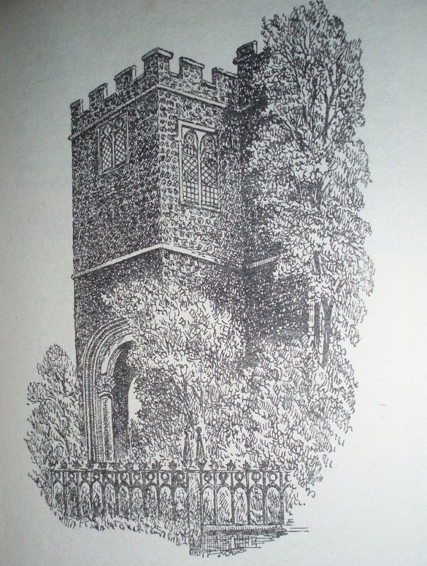
All Hallows Staining All Hallows Staining was a church located at the junction of Mark Lane and Dunster Court. The first mention of the church was in the late 12th century – ’Staining’ in this context means ’stone’, distinguishing it from the other churches called All Hallows in the City of London, which were wooden.
The old church survived the Great Fire in 1666 but collapsed in 1671. The church was rebuilt in 1674.
The parishes of All Hallows Staining and nearby St Olave Hart Street were combined in 1870. All Hallows Staining was demolished, leaving only the tower.
After St Olave Hart Street was badly damaged in 1941, between 1948 and 1954, a prefabricated church stood on the site of All Hallows Staining known as St Olave Mark Lane. The tower of All Hallows Staining was used as the chancel.
The tower is maintained by the Worshipful Company of Clothworkers, one of the livery companies of the City of London.
TUM Book Club: Old Covent Garden The magic of the old Covent Garden Market is evoked through Clive Boursnell’s photographs, taken over the course of numerous visits to Covent Garden in the 1960s and 1970s. In the late 1960s and early 1970s Clive Boursnell, then a young photographer, shot thousands of photographs of the old Covent Garden, documenting the end of an era before the markets moved out of central London. Boursnell captured these last days of the market over a period of six years, from 1968 until the market’s closure, in a series of beautiful portraits of the feisty life of a city institution.
’St Pancras Smallpox Hospital, London’
This hospital near Battle Bridge, was demolished to make way for St Pancras railway station. The Hospital was replaced by the Highgate Smallpox and Vaccination Hospital, erected in 1848–1850